The earthmoving industry has always lived and died by numbers — cubic yards moved, tons hauled, materials delivered and received. For decades, those numbers were estimated by boots on the ground using survey rods, tape measures, and educated guesses. Today, LiDAR (Light Detection and Ranging) scanning has fundamentally transformed that process, delivering point cloud data with millimeter-level accuracy that eliminates costly disputes, reduces material waste, and accelerates project timelines.
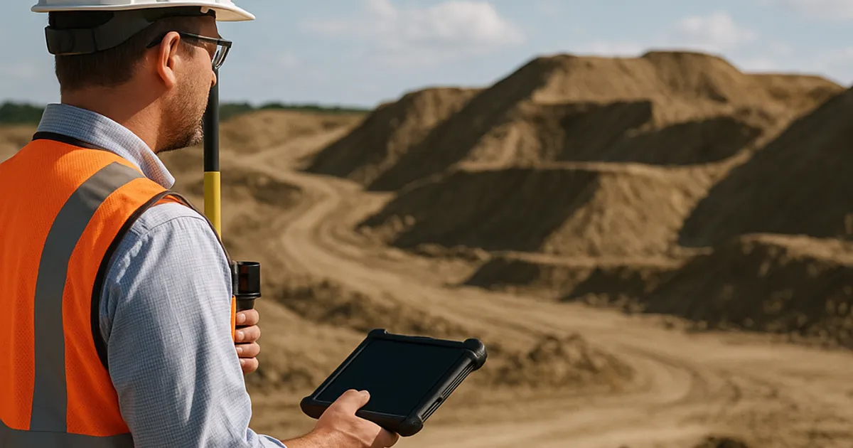
In 2026, LiDAR technology is no longer reserved for billion-dollar infrastructure projects. Drone-mounted sensors, compact terrestrial scanners, and cloud-based processing software have democratized access to this technology, making it practical for mid-size earthwork contractors, aggregate producers, and site developers across North America. Whether you're managing a 50,000-ton aggregate stockpile, preparing a bid for a highway cut-and-fill project, or documenting existing conditions before breaking ground, LiDAR scanning is rapidly becoming the industry standard — and the contractors who haven't adopted it yet are leaving real money on the table.
This comprehensive guide covers everything earthwork professionals need to know about LiDAR scanning: how the technology works, what it costs, how it integrates into project workflows, and how it's reshaping material procurement and logistics from Seattle to San Diego.
What Is LiDAR and How Does It Work?
LiDAR stands for Light Detection and Ranging. The technology works by emitting rapid pulses of laser light — modern systems fire anywhere from 300,000 to over 1,000,000 pulses per second — and measuring the precise time it takes for each pulse to bounce back from a surface. By combining those time-of-flight measurements with GPS coordinates and inertial measurement unit (IMU) data, the system builds an extraordinarily dense three-dimensional map of everything within its field of view.
The result is called a point cloud — a massive dataset of georeferenced X, Y, Z coordinates that together represent the shape, texture, and elevation of a scanned environment. A single aerial LiDAR pass over a 10-acre construction site might generate 50 to 200 million individual data points. When processed and visualized, that point cloud looks remarkably like a photograph of the real world, but it carries dimensional accuracy that photographs simply cannot provide.
The Physics Behind the Pulse
Most construction-grade LiDAR systems use near-infrared laser wavelengths (typically 905nm or 1550nm). The 1550nm wavelength has become increasingly common for aerial applications because it is eye-safe at higher power levels, allowing for denser pulse rates and better ground penetration through sparse vegetation. The time-of-flight measurement is accurate to within a few nanoseconds, which translates to positional accuracy measured in millimeters at typical operating distances.
Modern systems also capture return intensity — essentially how reflective each surface is — which helps automated classification algorithms distinguish between bare ground, vegetation, structures, vehicles, and stockpiles. This multi-return capability is especially valuable on construction sites where equipment, site huts, and material piles need to be separated from the underlying terrain for accurate volume calculations.
LiDAR vs. Photogrammetry
LiDAR is frequently compared to photogrammetry (structure-from-motion using drone photography), and both technologies have their place. Photogrammetry is generally less expensive to capture — any drone with a quality camera can collect the imagery — but it requires good lighting, struggles in shadow areas, and cannot penetrate vegetation to reach bare ground. LiDAR is hardware-intensive and typically costs more per flight, but it delivers superior accuracy in low-light conditions, can penetrate sparse tree canopy, and produces more reliable volumetric measurements on irregular surfaces like rock piles and aggregate stockpiles.
For stockpile measurement and precise cut-and-fill calculations, most surveyors and geospatial engineers recommend LiDAR or a hybrid LiDAR-photogrammetry approach.
Types of LiDAR Systems Used in Earthwork and Construction
Not all LiDAR systems are created equal. The construction and earthwork industries rely on several distinct categories of scanning hardware, each with specific use cases, cost structures, and accuracy profiles.
Aerial LiDAR (UAV-Mounted)
Drone-mounted LiDAR sensors represent the fastest-growing segment of the construction technology market. A typical UAV LiDAR system pairs a multi-return laser scanner with a high-precision GNSS receiver and IMU unit. Popular platforms in 2026 include the DJI Zenmuse L2, Velodyne Alpha Prime adapted for UAV use, and the YellowScan Mapper series.
Aerial LiDAR is ideal for:
- Large earthwork sites (5+ acres)
- Linear projects (road corridors, pipeline routes)
- Regular stockpile inventory surveys
- Cut-and-fill volume calculations across broad areas
- Change detection between survey epochs
Flight time for a 20-acre site at typical survey altitudes (50–100 meters AGL) runs approximately 30–60 minutes of actual scan time, with ground control point (GCP) setup and post-processing adding several hours. Absolute positional accuracy for modern UAV LiDAR systems ranges from 2–5 cm (horizontal) and 3–10 cm (vertical), depending on GCP density and baseline correction methods.
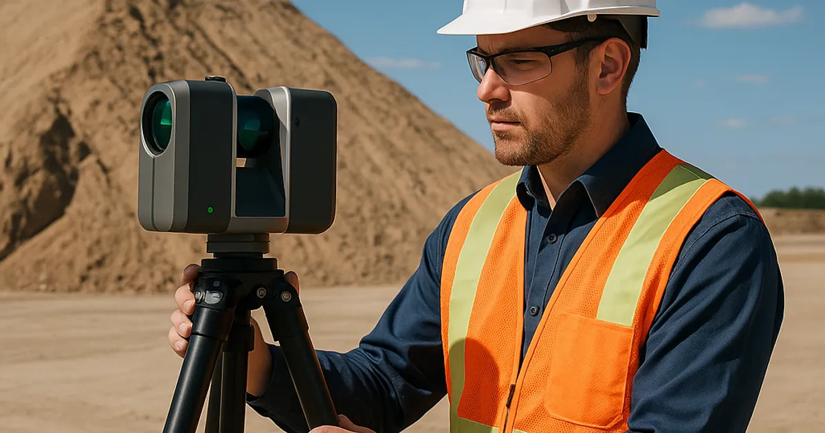
Terrestrial LiDAR Scanners (TLS)
Terrestrial LiDAR scanners are tripod-mounted instruments that capture 360-degree point clouds from fixed positions. Leading manufacturers include Leica Geosystems (RTC360), FARO Technologies (Focus series), and Trimble (TX8). These systems are well-suited for:
- Confined site documentation (tunnels, retaining walls, culverts)
- High-accuracy stockpile measurement where drone flight isn't practical
- Structural as-built documentation
- Indoor scanning of processing facilities
TLS systems typically achieve higher point density and accuracy than aerial systems — often sub-centimeter — but require multiple setups around a site to achieve full coverage, making them more labor-intensive for large open areas.
Mobile LiDAR Systems
Mobile LiDAR mounts scanners on vehicles — trucks, all-terrain vehicles, or even backpack rigs — allowing continuous scanning while in motion. Companies like Trimble, Leica, and RIEGL offer mobile mapping systems used for road corridor surveys, quarry documentation, and facility mapping. Mobile systems sacrifice some accuracy compared to TLS but dramatically reduce field time over large linear projects.
LiDAR-Equipped Machine Control
An emerging application integrates LiDAR sensors directly onto heavy equipment. Companies including Trimble Construction and Komatsu have developed intelligent machine control systems that use onboard sensors — including LiDAR — to provide real-time guidance to dozer and grader operators. These systems compare the existing surface against the design model continuously, giving operators centimeter-level feedback on cut and fill requirements without waiting for a separate survey.
LiDAR for Stockpile Volume Measurement: The Business Case
For aggregate producers, quarry operators, and earthwork contractors managing large material inventories, stockpile measurement accuracy is a direct financial issue. Errors in volume estimates translate immediately into incorrect inventory reporting, payment disputes, and procurement miscalculations.
Traditional stockpile measurement methods — walking the pile with a measuring tape, using a total station from a single vantage point, or applying generic geometric formulas — routinely produce errors of 5–15% or more. On a 50,000-ton aggregate stockpile, a 10% error represents 5,000 tons of material — potentially hundreds of thousands of dollars in inventory discrepancy.
What LiDAR Delivers for Stockpile Measurement
LiDAR-based stockpile surveys deliver typical accuracy within 1–3% of actual volume when conducted properly with adequate GCPs and calibrated equipment. The workflow typically proceeds as follows:
- Pre-survey preparation: Establish or locate existing ground control points around the stockpile area. GCPs should be evenly distributed and include points at the base perimeter of all stockpiles.
- Data capture: Fly the drone or position the TLS scanner to achieve complete surface coverage of all stockpile faces. Shadowed areas beneath steep pile faces require careful flight planning or supplemental scans.
- Point cloud processing: Raw scan data is processed through software such as Trimble Business Center, Bentley ContextCapture, or specialized stockpile platforms like Stockpile Reports or Propeller Aero. Processing classifies ground points from stockpile surface points and generates a bare-earth model (DTM) beneath the pile.
- Volume calculation: The software calculates volume by comparing the current pile surface to the base plane (either a stored pre-pile terrain model or a best-fit base plane derived from the perimeter). The result is reported in cubic yards, cubic meters, or weight equivalent using a known material density.
- Reporting: Output includes volume tables, color-coded elevation maps, cross-section profiles, and exportable data for integration with inventory management systems.
Cost Comparison: Traditional vs. LiDAR Survey
| Method | Time on Site | Accuracy | Cost Per Survey | Repeat Frequency |
|---|---|---|---|---|
| Manual tape/rod measurement | 4–8 hours | ±10–20% | $500–$1,500 | Monthly |
| Total station survey | 4–6 hours | ±3–8% | $1,500–$3,500 | Monthly |
| Drone photogrammetry | 1–2 hours | ±2–5% | $800–$2,000 | Weekly–Monthly |
| UAV LiDAR scan | 1–3 hours | ±1–3% | $1,500–$4,000 | Weekly–Monthly |
| Terrestrial LiDAR | 2–6 hours | ±0.5–2% | $2,000–$5,000 | Monthly–Quarterly |
The economics become compelling when you factor in the cost of disputes, inventory write-downs, and procurement errors that accurate measurement prevents. Many large quarry operators report that switching to LiDAR-based inventory management pays for itself within two to three survey cycles.
Connecting Accurate Volumes to Smarter Material Procurement
Knowing exactly how much material you have — or how much you need — is the foundation of efficient procurement. Contractors who have precise cut-and-fill volume data are better positioned to source material efficiently, whether they're looking to place excess excavated dirt or source clean fill for a project. Platforms like DirtMatch connect earthwork contractors with nearby sources of fill dirt, topsoil, rock, and aggregate, making it straightforward to match your verified volume requirements with available material in your region — whether you're managing a project in Denver or handling a dirt exchange in Los Angeles.
Cut-and-Fill Volume Calculations with LiDAR
Cut-and-fill balancing is one of the most fundamental calculations in earthwork contracting. Getting it wrong on a large site can mean importing tens of thousands of cubic yards of fill that you didn't need to buy, or paying to haul away material that could have been used on-site. LiDAR scanning transforms this process from an art form into a precise engineering workflow.
The Traditional Challenge
Historically, cut-and-fill calculations relied on cross-section survey data collected at regular intervals across a site, with volumes calculated using the average-end-area method or prismoidal formula. The accuracy of this approach depends entirely on the density of survey cross-sections — more sections mean better accuracy, but also more field time and cost. On irregular terrain, large sections can miss significant volume in between sampling points.
LiDAR-Based Cut-and-Fill Workflow
With LiDAR, the entire existing surface is captured as a continuous model. The process for cut-and-fill analysis looks like this:
Step 1 — Pre-construction existing conditions survey: A LiDAR scan captures the existing ground surface as a dense point cloud. This is processed into a Digital Terrain Model (DTM) — a triangulated surface representing bare earth elevation at every point across the site.
Step 2 — Import design surface: The proposed finished grade (from civil engineering design software like Civil 3D or OpenRoads) is imported into the analysis platform.
Step 3 — Surface comparison: The software calculates the difference between the existing DTM and the design surface at every point, classifying areas where cut is required (existing grade higher than design) and where fill is required (existing grade lower than design).
Step 4 — Volume summation: Total cut and fill volumes are summed across the site, with shrinkage and swell factors applied according to material-specific soil data. Cut volumes are converted to compacted fill equivalents using appropriate bulking factors.
Step 5 — Balance optimization: Modern earthwork software can generate mass haul diagrams showing the optimal movement of material across the site to minimize haul distances and external import/export.
Step 6 — Progress monitoring: Periodic LiDAR scans throughout construction allow real-time comparison against the original plan, providing early warning when earthwork is trending over or under budget.
Accuracy Standards and Tolerances
For highway and DOT-funded projects, cut-and-fill calculations are subject to specific accuracy requirements. The Federal Highway Administration provides guidance on earthwork quantity measurement standards for federally funded projects, and many state DOTs now explicitly accept LiDAR-derived volumes in lieu of traditional survey cross-sections, provided the data meets specified accuracy thresholds. Most state specifications require vertical accuracy of 0.1 feet (3 cm) or better for earthwork quantity surveys — well within the capability of properly executed UAV LiDAR surveys.
Site Documentation: Building the As-Built Record with Point Clouds
Beyond volume calculations, LiDAR has become an essential tool for site documentation — creating an accurate, timestamped record of site conditions before, during, and after construction. This documentation serves multiple critical purposes: dispute resolution, regulatory compliance, as-built verification, and long-term facility management.
Pre-Construction Existing Conditions Capture
Pre-construction LiDAR scans establish an irrefutable baseline of site conditions before any work begins. This is increasingly standard practice on major earthwork projects because it protects all parties:
- Contractors have evidence of pre-existing site conditions, eliminating disputes about who caused what damage
- Owners have documented baselines for verifying contractor claims about existing conditions that may affect cost
- Environmental compliance benefits from documented pre-disturbance topography for stormwater and erosion control modeling
For projects near regulated waterways or wetlands, pre-construction LiDAR can document buffer zones, drainage patterns, and adjacent sensitive areas in sufficient detail to demonstrate compliance with EPA stormwater construction permit requirements — an increasingly important consideration as regulatory enforcement has tightened through 2025 and into 2026.
Progress Documentation and Change Order Support
Monthly or bi-weekly LiDAR scans during construction create a time-stamped record of work completed. This documentation directly supports:
- Pay application verification: Scan-derived earthwork quantities provide objective documentation for monthly progress payments
- Change order justification: When design changes alter earthwork scope, before-and-after scans provide unambiguous volume documentation for pricing change orders
- Schedule analysis: Comparing planned versus actual earthwork progress across scan epochs helps project managers identify areas where work is ahead or behind schedule
As-Built Verification
At project completion, a final LiDAR scan generates as-built documentation that can be compared directly against design intent. Earthwork contractors can demonstrate — with geometric proof — that finished grades meet specification tolerances. This is particularly valuable for:
- Subgrade elevation verification on roadway projects
- Detention basin and retention pond geometry verification
- Slope and berm as-built documentation
- Utility trench backfill settlement monitoring
Point Cloud Processing Software: The Workflow Behind the Data
Raw LiDAR data is not inherently useful without processing. The point cloud workflow from raw scan to actionable deliverable involves several key software tools and steps that earthwork contractors and their survey partners need to understand.
Key Processing Steps
1. Strip adjustment and trajectory processing: For aerial data, the raw GPS/IMU trajectory is post-processed against base station data (or CORS network data) to refine the position and attitude of the sensor at every moment of the flight. This step is critical for achieving centimeter-level accuracy and requires specialized software like Applanix POSPac or NovAtel Inertial Explorer.
2. Point cloud registration: Multiple scan positions (for TLS) or flight lines (for aerial) are aligned into a single unified coordinate system using GCP targets or automatic surface-matching algorithms.
3. Classification and filtering: Automated algorithms classify points into ground, vegetation, structures, noise, and other categories. For earthwork applications, accurate ground classification is essential for correct volume calculations. Common classification tools include LAStools, TerraScan, and native functions within platforms like Trimble Business Center.
4. DTM generation: Classified ground points are triangulated into a Digital Terrain Model — the foundational surface model used for all volume and grade analysis.
5. Volume and surface analysis: Specialized modules calculate volumes, generate contours, produce cross-sections, and compare against design surfaces.
6. Deliverable generation: Final outputs include PDFs, DXF/DWG files for CAD import, LAS/LAZ point cloud files, GeoTIFF rasters, and web-viewable 3D models depending on project requirements.
Popular Software Platforms in 2026
| Software | Primary Use | Price Range |
|---|---|---|
| Trimble Business Center | Full earthwork analysis suite | $500–$1,200/month |
| Autodesk Civil 3D + InfraWorks | Design integration with scan data | $350–$800/month |
| Bentley ContextCapture | Reality modeling and point cloud | $300–$900/month |
| Propeller Aero | Stockpile and site management | $400–$800/month |
| DroneDeploy | UAV mission planning + processing | $200–$500/month |
| LAStools | Point cloud processing (open-source base) | Free–$450/year |
| Pix4D Matic | Hybrid LiDAR/photogrammetry processing | $300–$700/month |
Many of these platforms now offer cloud-based processing, eliminating the need for high-end workstation hardware on the contractor side. Scan data uploads to the cloud, processing runs automatically, and results are available through a web browser within hours.
Find or Post Dirt, Rock & Aggregate
Join thousands of contractors using DirtMatch to buy, sell, and exchange earthwork materials.
Try DirtMatch FreeRegulatory Compliance and Legal Admissibility of LiDAR Data
As LiDAR becomes ubiquitous in construction, questions about the legal standing of scan-derived measurements have largely been resolved in the industry's favor. Survey-grade LiDAR data, collected and processed by qualified practitioners, is now widely accepted in legal proceedings, dispute resolution, and regulatory submissions.
Survey Licensing Requirements
The legal status of LiDAR-derived surveys varies by state. In most jurisdictions, a Licensed Professional Surveyor (PLS) or Licensed Land Surveyor (LS) must either perform or directly supervise and certify LiDAR surveys used for legal boundary determinations or government submissions. However, for internal project management purposes — stockpile inventory, progress monitoring, change order documentation — unlicensed practitioners with appropriate training can legally collect and process LiDAR data.
Contractors considering in-house LiDAR programs should consult their state's surveying licensing board to understand exactly what activities require professional licensure in their jurisdiction.
ASTM Standards for Volume Measurement
ASTM International has developed standards relevant to volumetric measurement accuracy, and LiDAR-derived volumes are increasingly referenced in the context of ASTM guidelines for material quantity verification. While no single ASTM standard specifically governs LiDAR survey methodology, the general principles of measurement accuracy, calibration, and documentation that underpin ASTM's testing frameworks apply equally to scan-derived measurements.
Evidentiary Use in Disputes
LiDAR point cloud data has been admitted as evidence in construction arbitration and litigation with increasing frequency. The key factors for admissibility include:
- Documented calibration records for the scanning equipment
- Preserved raw data files with unbroken chain of custody
- Qualified expert testimony explaining the methodology
- Demonstrated accuracy through GCP residuals and redundant measurements
Contractors who establish consistent scan protocols and archive raw data create a powerful evidentiary record that protects them in disputes over earthwork quantities, damage claims, and project scope.
Implementation Guide: Starting a LiDAR Program for Earthwork Operations
For earthwork contractors ready to integrate LiDAR into their operations, the path from interest to implementation involves several key decisions. The right approach depends on your project volume, scan frequency requirements, budget, and in-house technical capacity.
Option 1: Outsource to a Geospatial Service Provider
For contractors who need occasional LiDAR surveys — perhaps quarterly stockpile inventories or one-time pre-construction documentation — outsourcing to a professional drone survey or geospatial firm is often the most cost-effective approach. Typical costs run $1,500–$5,000 per survey depending on site size and deliverable complexity. Survey firms handle equipment, software, processing, and deliverable preparation, minimizing your team's required expertise.
When evaluating service providers, look for:
- FAA Part 107 certification for drone operations
- Survey licensure (PLS) for legally certifiable deliverables
- Demonstrated experience in construction/earthwork applications specifically
- Clear specification of accuracy guarantees and GCP methodology
- References from earthwork or aggregate industry clients
Option 2: Hybrid In-House/Outsourced Model
Many mid-size contractors invest in UAV hardware and collect their own aerial data, then outsource point cloud processing to specialist firms. This model captures some of the cost savings of in-house scanning while avoiding the software licensing and training investment required for sophisticated processing workflows. A capable UAV platform with LiDAR sensor ranges from $15,000 to $60,000 depending on specifications.
Option 3: Full In-House LiDAR Capability
Larger contractors — those running multiple simultaneous projects, operating quarries, or managing significant earthwork volume annually — often justify full in-house capability. This includes:
- UAV LiDAR system: $20,000–$60,000
- Ground control equipment: $5,000–$15,000
- Processing software licenses: $5,000–$15,000/year
- Workstation hardware (if not cloud-processing): $5,000–$10,000
- Training and certification: $2,000–$5,000
- Total initial investment: $37,000–$105,000
For contractors running 20+ scans per year, the per-scan cost of in-house capability quickly drops below outsourced rates, and the operational advantage of on-demand scanning capability adds additional value.
Training and Certification Resources
The geospatial industry has developed a robust training ecosystem for LiDAR practitioners. Key resources include manufacturer training programs (DJI Terra, Trimble Academy), university certificate programs in geospatial technology, and industry associations including the AGC of America, which has increasingly incorporated geospatial technology content into its education offerings for construction professionals.
LiDAR Integration with Material Tracking and Procurement
The most forward-thinking earthwork contractors in 2026 are integrating LiDAR-derived volume data directly into their material tracking and procurement workflows. This integration closes the loop between what's been moved, what's been received, and what still needs to be sourced or placed.
The Volume-to-Procurement Connection
Consider a large site development project where the grading contractor needs to import 45,000 cubic yards of structural fill over a 12-week schedule. With weekly LiDAR scans tracking actual fill placement progress, the project manager has real-time visibility into:
- Actual fill placed to date vs. scheduled placement
- Remaining fill requirement, updated continuously
- Rate of fill delivery needed to maintain schedule
- Early identification of areas where fill thickness deviates from design
This real-time volume intelligence allows procurement decisions to be made dynamically — accelerating deliveries when placement is ahead of schedule, or adjusting logistics when weather or other factors slow progress.
Reducing Wasted Hauls with Accurate Volume Data
One of the most significant cost savings LiDAR delivers is in eliminating wasted trucking. When contractors know precisely how much material they need — not an estimate padded with uncertainty — they can right-size their trucking procurement and avoid paying for excess hauls. In regions with active material exchange markets, precise volume data also enables contractors to participate more effectively in spot material markets, buying and selling excess material without carrying large inventory positions.
If your project generates surplus excavated material, DirtMatch makes it straightforward to list that material and connect with contractors who need fill in your area — turning what might have been a disposal cost into a recovered value. Contractors managing dirt exchanges in markets like Denver or San Francisco have found that precise LiDAR-verified quantities significantly speed up the matching process by eliminating the uncertainty that typically surrounds material listings.
The Future of LiDAR in Earthwork: Trends Shaping 2026 and Beyond
LiDAR technology continues to evolve rapidly, and several emerging trends are particularly relevant for earthwork contractors looking ahead.
AI-Powered Point Cloud Analysis
Artificial intelligence and machine learning are dramatically accelerating point cloud processing. Algorithms that previously required hours of manual classification work now run automatically in minutes, with accuracy that exceeds manual methods in many scenarios. AI tools can automatically identify stockpile boundaries, classify material types based on surface texture and reflectivity, and flag areas where scan data suggests unexpected subsidence or slope instability.
Real-Time LiDAR from Autonomous Equipment
As autonomous and semi-autonomous construction equipment moves from experimental to operational, onboard LiDAR becomes the sensory foundation for machine navigation and work verification. Autonomous dozers and scrapers that can self-verify their cut and fill progress in real time represent a convergence of LiDAR, machine control, and autonomous operation that will reshape earthwork productivity metrics within the next five years.
Lower Hardware Costs and Higher Accessibility
LiDAR hardware costs have declined approximately 60–70% over the past five years, driven by automotive LiDAR development for self-driving vehicles. That trend is expected to continue, putting capable LiDAR hardware within reach of smaller contractors and pushing capabilities upward across all price points.
Integration with Digital Twin Platforms
Digital twins — continuously updated virtual models of physical projects — are incorporating LiDAR scan data as a primary input. As-built conditions, material inventories, and earthwork progress are maintained in real-time digital models that all project stakeholders can access. For complex infrastructure projects, this integration is transforming how owners, designers, and contractors collaborate throughout construction.
Getting Your Team Ready: Training, Safety, and Compliance
Implementing LiDAR technology successfully requires more than hardware and software — it requires trained personnel, clear operational protocols, and attention to regulatory compliance.
FAA Compliance for Drone Operations
All commercial drone operations in the United States require FAA Part 107 certification for the Remote Pilot in Command. Operations in controlled airspace — which covers many urban construction sites — require LAANC authorization or a formal FAA waiver. Contractors operating near airports, heliports, or military facilities face additional restrictions that must be carefully navigated before each operation.
Beyond FAA requirements, site-specific safety protocols for drone operations on active construction sites should address:
- Exclusion zones around operating heavy equipment
- Communication protocols with site foreman during flight operations
- Emergency procedures for loss of control or fly-away scenarios
- PPE requirements for ground crew during flight operations
Building Internal Competency
The most successful in-house LiDAR programs invest in systematic training rather than relying on one individual. Cross-training ensures that scan operations can proceed even when a key team member is unavailable, and it distributes the knowledge base across the organization. Develop standard operating procedures (SOPs) for each type of scan — stockpile survey, progress documentation, pre-construction capture — and document them thoroughly to support consistent execution and onboarding of new team members.
As you build your team's technical capabilities, you'll find that the same data-driven culture that enables LiDAR integration also improves bidding accuracy, project controls, and material procurement efficiency. Contractors who embrace measurement precision across their operations are well-positioned to take full advantage of platforms like DirtMatch Pro, which provides enhanced tools for matching verified material volumes with projects in your market — making every cubic yard count.
Conclusion: Measurement Precision as a Competitive Advantage
LiDAR scanning for volume calculations and site documentation has crossed the threshold from emerging technology to operational standard. In 2026, the question for earthwork contractors is no longer whether to adopt LiDAR, but how quickly and how deeply to integrate it into their project workflows.
The business case is clear: reduced measurement uncertainty, faster survey turnaround, objective documentation for disputes and compliance, and tighter integration between volume data and material procurement. Contractors who have made the investment report that LiDAR pays for itself through reduced waste, fewer disputes, and more competitive bidding — often within the first year of operation.
Whether you're starting with outsourced scans for your most important projects or building a full in-house capability, the first step is the same: commit to measurement precision as a core operational value. From that foundation, every other benefit of LiDAR technology follows naturally.
To explore how precise volume data and smarter material matching can work together for your earthwork operation, get started with DirtMatch and discover how the platform connects contractors with the materials and opportunities that keep projects moving.