The earthwork industry has undergone a quiet revolution over the past decade, and by 2026, that revolution is fully mainstream. GPS machine control — once reserved for large infrastructure firms with deep pockets — is now standard practice on competitive job sites from suburban housing developments to major highway corridors. Excavators and dozers equipped with grade control systems are faster, more accurate, and more profitable than their conventionally operated counterparts.
But adopting this technology isn't as simple as bolting a receiver onto a cab roof. It requires understanding the hardware, software, data workflows, and operational culture that make GPS machine control actually work. Whether you're an owner-operator evaluating your first system or a large contractor building out a fleet-wide technology strategy, this guide covers everything you need to know about GPS grade control in 2026.
What Is GPS Machine Control and How Does It Work?
GPS machine control — also referred to as grade control or 3D machine guidance — is a system that uses real-time satellite positioning to track the exact location and elevation of a machine's cutting edge (the blade tip of a dozer or the bucket teeth of an excavator) and compares that position against a digital design model of the finished surface.
At its core, the system consists of several integrated components:
- GNSS receivers: Antennas mounted to the machine (typically one or two) that receive signals from GPS, GLONASS, Galileo, and BeiDou constellations simultaneously. Multi-constellation support is now standard in 2026, dramatically improving accuracy and uptime.
- Inertial measurement units (IMUs): Sensors that track machine tilt, pitch, and roll — critical for excavators where the boom, arm, and bucket are constantly moving.
- Machine sensors: Rotary encoders and angle sensors on excavator linkages that calculate exact bucket tooth position based on the geometry of the boom arm and stick.
- In-cab displays: Touchscreen monitors that show the operator a real-time cross-section view, plan view, and grade guidance interface — indicating how far above or below design grade they are at any given moment.
- Design files: Digital terrain models (DTMs) or 3D surfaces created in design software (Civil 3D, Trimble Business Center, Topcon MAGNET, etc.) and loaded onto the machine.
- Communication infrastructure: Cellular modems or job-site radios that enable real-time data transfer between machines and the office.
The result is a system where an operator always knows exactly where their cutting edge is in three-dimensional space, measured against the engineered design. Instead of chasing grade stakes, reading paper plans, or relying on a grade checker walking the site, the machine itself becomes the instrument of precision.
The Evolution from Grade Stakes to 3D Machine Control
Not long ago, earthwork accuracy relied almost entirely on a system of wooden stakes driven into the ground by surveyors, combined with the skill and experience of operators who read those stakes to hit the right elevations. This method worked — but it was slow, labor-intensive, and vulnerable to human error, weather, and the simple reality that stakes get knocked over by equipment.
The first generation of machine guidance systems in the late 1990s and early 2000s used laser-based systems that were effective on flat, horizontal surfaces like parking lots and building pads. A rotating laser transmitter would project a reference plane, and a receiver mounted on a dozer blade would catch the beam and signal the operator — or the automatic blade control — when they were on grade.
GPS-based systems emerged in the mid-2000s and offered a fundamentally different capability: the ability to work on complex 3D surfaces — variable slopes, swales, road crowns, pond bottoms, and graded terraces — without any physical infrastructure on the ground beyond a base station. By 2026, the technology has evolved through several generations:
- 2D laser systems (still in use for simple grading): Accurate to ±3mm on flat or single-slope surfaces.
- 3D GPS/GNSS guidance: Accurate to ±15–25mm for semi-automatic systems.
- 3D GPS with automatic blade/bucket control: Accurate to ±10–15mm with closed-loop hydraulic control.
- GPS + IMU hybrid systems: Combining satellite positioning with inertial data for accuracy even under bridges, near structures, or in areas with limited sky view.
- RTK (Real-Time Kinematic) correction networks: Provide centimeter-level accuracy by using a fixed base station or a virtual reference station (VRS) network.
Leading manufacturers including Trimble Construction, Caterpillar, and Komatsu have each developed proprietary machine control ecosystems that integrate hardware, software, and cloud connectivity into tightly unified platforms.
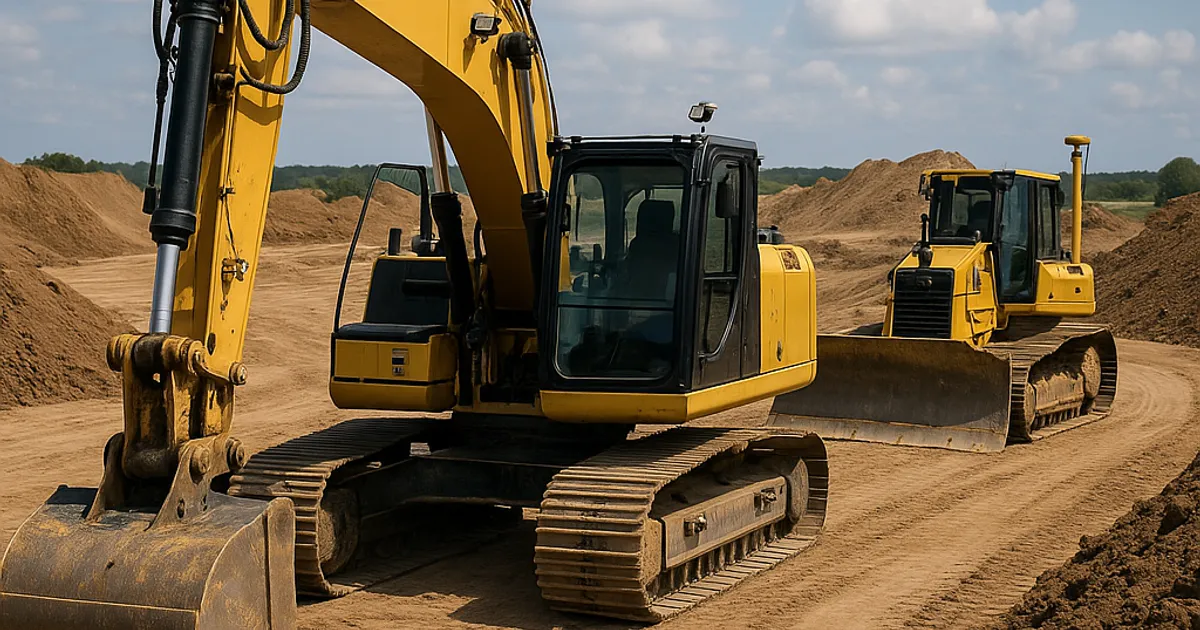
GPS Machine Control on Dozers: How Blade Automation Works
Dozers represent perhaps the most mature application of GPS machine control. Because the cutting edge of a dozer blade is a fixed, known geometry in relation to the machine frame, the math required to calculate blade tip position is simpler than on an excavator. This makes dozer machine control both highly accurate and highly reliable.
Semi-Automatic vs. Fully Automatic Blade Control
Most GPS dozer systems offer both a guidance mode (where the in-cab display shows the operator how much to raise or lower the blade) and a fully automatic mode (where the hydraulics respond directly to the grade control system without operator input). In automatic mode, the operator focuses on travel direction, speed, and pattern — the system handles grade.
Fully automatic blade control typically delivers finished grades accurate to ±12mm or better, compared to ±25–50mm for a skilled operator working from stakes. On large grading projects, this precision translates directly into reduced material waste, fewer machine passes, and dramatically less over-excavation or over-fill.
Real-World Dozer Productivity Gains
Contractors who have adopted GPS blade control consistently report:
- 15–25% reduction in total machine hours per acre of finished grade
- 50–80% reduction in staking costs — surveyors are still needed for control points and verification, but daily staking crews are largely eliminated
- 30–50% reduction in rework caused by grade errors
- Faster crew deployment — experienced operators with machine control can hold grade on complex surfaces that previously required multiple passes and frequent grade checks
For a dozer working on a $2 million commercial site grading contract, eliminating even 20% of the machine hours at $200/hour represents $40,000 or more in direct cost savings. That's meaningful margin on a competitive bid.
GPS Machine Control on Excavators: The More Complex Application
While dozer machine control is relatively straightforward, excavator machine control is a more sophisticated engineering challenge. The excavator's working tool — the bucket — is at the end of a three-segment linkage (boom, arm/stick, and bucket) that moves through a constantly changing geometry. Calculating the exact position of the bucket teeth requires knowing the angle of each linkage segment precisely, in real time, under dynamic loading conditions.
How Excavator Position Is Calculated
Modern excavator machine control systems use a combination of:
- IMUs on the boom and arm: These inertial sensors track the angle of each segment relative to gravity, typically to within 0.05–0.1 degrees of accuracy.
- GNSS receivers on the cab: One or two antennas establish the machine's precise XYZ position and heading in the site coordinate system.
- Depth sensors or encoders: In some systems, additional sensors confirm cylinder extension to cross-check IMU-derived angles.
- Real-time kinematic correction: An RTK base station or network subscription corrects GPS signal errors to deliver centimeter-level horizontal and vertical accuracy.
The in-cab display synthesizes all this sensor data and shows the operator exactly where the bucket teeth are in relation to the design surface — typically displayed as a color-coded depth-to-grade indication and a cross-section profile.
Excavator Applications That Benefit Most
GPS machine control on excavators delivers the greatest ROI in these specific applications:
| Application | Key Benefit | Accuracy Requirement |
|---|---|---|
| Utility trench excavation | Precise invert elevations | ±15–25mm |
| Pond and detention basin grading | Complex 3D surfaces | ±25mm |
| Road subgrade preparation | Consistent sub-base depth | ±15mm |
| Slope and embankment cutting | Accurate slope ratios | ±20mm |
| Foundation excavation | Depth and level control | ±15mm |
| Topsoil stripping | Consistent strip depth | ±25mm |
For utility contractors, hitting the correct pipe invert elevation on the first dig — without over-excavating and backfilling with granular material — can save thousands of dollars per linear mile of installation. Projects in high-cost markets like the dirt exchange in San Francisco or the dirt exchange in Los Angeles see especially strong returns, where over-excavation and imported fill costs can run $30–$60 per ton.
Understanding RTK vs. Network RTK Correction Systems
The accuracy of any GPS machine control system depends on the quality of its position correction data. Raw GPS signals from satellites alone are only accurate to about ±1–3 meters — far too imprecise for grade control work. Correction signals close this gap to centimeter-level accuracy.
Traditional RTK Base Stations
A traditional RTK setup places a GPS base station at a known control point on or near the job site. The base station transmits correction data to each machine via radio link. This approach works reliably on isolated job sites where the base station can be positioned safely and powered continuously.
Limitations include the cost of setting up and moving the base station, signal range limitations (typically 5–10km), and the need for a surveyor to establish the base station on a control point before operations can begin.
Network RTK (VRS Networks)
Network RTK services — such as Trimble RTX, Leica SmartNet, or state DOT-operated CORS (Continuously Operating Reference Station) networks — eliminate the need for a job-site base station entirely. Instead, correction data is delivered over cellular to each machine individually, using a virtual reference station computed from a network of fixed base stations.
By 2026, Network RTK services cover most major metro areas in the United States and many rural regions, though coverage gaps still exist in remote areas. Subscription costs typically run $1,500–$3,500 per machine per year — a fraction of the savings generated.
Accuracy Comparison
| Correction Method | Horizontal Accuracy | Vertical Accuracy | Infrastructure Needed |
|---|---|---|---|
| Raw GNSS (no correction) | ±1–3m | ±2–5m | None |
| SBAS (WAAS) | ±1–3m | ±3–5m | None |
| Local RTK Base Station | ±10–20mm | ±15–25mm | Base station + radio |
| Network RTK (VRS) | ±10–20mm | ±15–25mm | Cellular connection |
| RTK + IMU Hybrid | ±8–15mm | ±10–20mm | Base or network |
The Digital Workflow: From Design File to Machine
GPS machine control is only as good as the data it runs on. The digital workflow that connects engineering design to machine operation is a critical — and often underestimated — piece of the system.
Step 1: Design Surface Creation
The project's civil engineer creates a grading plan that is exported as a digital terrain model (DTM) or triangulated irregular network (TIN) surface file. Common formats include DXF, LandXML, and proprietary formats for Trimble, Topcon, or Leica systems. Errors or ambiguities in the design surface — inconsistent breaklines, gaps in the TIN, or incorrect datum reference — will create errors in the field.
Step 2: Control Point Establishment
A licensed surveyor establishes control points on the job site and ties them into the project coordinate system (typically state plane coordinates with NAD83/NAVD88 datums). These control points are used to configure the RTK base station or verify Network RTK accuracy before grading begins.
Step 3: Machine Configuration and Calibration
Technicians configure each machine's system with the correct machine dimensions (boom length, stick length, bucket pin heights, antenna offsets, etc.) and upload the design surface files. A bucket calibration procedure verifies that the system is accurately representing bucket tooth position.
Step 4: On-Site Quality Verification
Before production begins, operators should verify system accuracy by digging to a known elevation and checking with a conventional level or total station. Most contractors require ±15mm agreement between the machine control readout and an independent survey check before trusting the system for production grading.
Step 5: As-Built Data Collection
Many contractors capture as-built data during operations — the machine records its position and depth at every point it touches, creating a continuous as-built survey of the finished surface. This data can be compared to the design surface in the office to verify compliance, identify problem areas, and create documentation for owner acceptance.
This seamless digital workflow also creates operational data that earthwork contractors can use to track material quantities moved — critical for projects where accurate earthwork volumes determine billing. Contractors who use DirtMatch to connect with nearby fill suppliers and receivers find that precise cut/fill quantity data from machine control systems makes it far easier to match their surplus or deficit material with the right partner.
Cost of GPS Machine Control Systems in 2026
Understanding the cost of GPS machine control requires separating hardware purchase costs, installation, software/subscriptions, and ongoing support.
Hardware and Installation Costs
| System Type | Hardware Cost (Per Machine) | Installation | Annual Software/Subscription |
|---|---|---|---|
| Dozer 2D Laser | $5,000–$12,000 | $500–$1,500 | $0–$500 |
| Dozer 3D GPS (aftermarket) | $35,000–$65,000 | $2,000–$5,000 | $2,000–$4,000 |
| Dozer 3D GPS (OEM factory-integrated) | $25,000–$45,000 | Included | $1,500–$3,500 |
| Excavator 3D GPS (aftermarket) | $40,000–$75,000 | $3,000–$6,000 | $2,000–$4,000 |
| Excavator 3D GPS (OEM factory-integrated) | $30,000–$55,000 | Included | $1,500–$3,500 |
| Fleet Management Integration | $1,000–$3,000/machine | $500/machine | $1,000–$2,500/year |
OEM-integrated systems — such as Cat's GRADE technology, Komatsu's Intelligent Machine Control (iMC 2.0), and John Deere's SmartGrade — offer the advantage of factory installation, tight integration with the machine's hydraulic and control systems, and often better blade/bucket response times. These systems typically cost less than aftermarket due to the volume OEMs achieve and simpler installation.
Aftermarket systems from Trimble, Topcon, Leica, and others offer flexibility to install on any machine brand and typically offer more open data ecosystems that integrate with multiple software platforms.
Return on Investment Analysis
For a single dozer working 1,500 hours per year on grading projects:
- Staking cost savings: $25,000–$50,000/year (eliminating or reducing grade checkers)
- Machine efficiency gain (15%): 225 hours × $200/hr = $45,000/year in recovered capacity
- Rework reduction (30%): $10,000–$30,000/year depending on project types
- Total annual benefit: $80,000–$125,000
- System cost (amortized over 5 years): $10,000–$15,000/year
For most contractors, GPS machine control pays for itself within 12–18 months of deployment on active projects.
Find or Post Dirt, Rock & Aggregate
Join thousands of contractors using DirtMatch to buy, sell, and exchange earthwork materials.
Try DirtMatch FreeManufacturer Ecosystems: Choosing the Right Platform
The machine control market in 2026 is dominated by a handful of major ecosystems, each with different strengths depending on your fleet composition, project types, and existing software.
Trimble Construction
Trimble is the most widely used aftermarket machine control platform globally. Their Earthworks Grade Control Platform offers 2D and 3D guidance and control for excavators and dozers, with cloud connectivity through Trimble WorksManager and WorksOS. The Trimble ecosystem integrates tightly with Trimble Business Center office software and Trimble's VRS Now Network RTK service.
Topcon Positioning
Topcon's MC-Max and 3D-MC systems are strong competitors, particularly popular among contractors who prefer open data formats and compatibility with third-party software. Topcon's Sitelink3D platform provides real-time fleet visibility and remote design updates.
Leica Geosystems (Hexagon)
Leica's iCON system is widely adopted in Europe and gaining U.S. market share. The Leica Geosystems ecosystem features strong integration with BIM (Building Information Modeling) workflows — increasingly important on complex civil projects.
OEM-Integrated Platforms
- Caterpillar GRADE: Factory-integrated on Cat dozers and excavators, with the Cat MineStar and VisionLink telematics ecosystem. Cat's semi-autonomous dozer capabilities have advanced significantly in 2026.
- Komatsu Intelligent Machine Control (iMC 2.0): Fully automatic blade control on dozers and semi-automatic bucket control on excavators. Komatsu Smart Construction integrates drone surveying, machine control, and cloud reporting.
- John Deere SmartGrade: Factory-integrated on John Deere G-series dozers, with full automatic blade control and integration with JDLink telematics.
Training Operators for GPS Machine Control
Technology alone doesn't create results — operator adoption and competency are the critical human factors that determine whether a machine control investment pays off. Many contractors who deploy GPS systems report that the biggest implementation challenge is not the technology itself but getting operators to trust it and use it correctly.
Why Experienced Operators Sometimes Resist
Veteran operators who have spent decades developing exceptional grade instincts can view machine control as a challenge to their expertise. This is a cultural issue as much as a technical one. The most successful implementations treat machine control as a tool that amplifies operator skill — not one that replaces it. A great operator with GPS runs faster, produces better grades, and takes on more complex surfaces than they could without it.
Effective Training Approaches
- Manufacturer-led operator training: Trimble, Topcon, and the OEMs all offer structured operator training programs, typically 8–16 hours for initial certification.
- In-field mentoring: Pairing less experienced operators with GPS-proficient mentors during their first projects with the system accelerates adoption.
- Gradual introduction: Start operators in guidance mode (information only) before switching to automatic control, so they understand what the system is doing.
- Office software training: Foremen and superintendents should understand how to load design files, review as-built reports, and troubleshoot basic system issues.
As the labor market for skilled equipment operators remains tight — a challenge that affects markets from the dirt exchange in Denver to the dirt exchange in Boston — GPS machine control also serves as a productivity multiplier for less experienced operators who can achieve acceptable grades with less time in the seat than would previously have been required.
Data Management, Cloud Connectivity, and Fleet Telematics
By 2026, GPS machine control has evolved from standalone machine guidance into a fully connected ecosystem where data flows continuously between machines, job-site supervisors, and office teams.
Real-Time Design Updates
One of the most operationally significant advances is the ability to push updated design files to machines in real time over cellular, without removing memory cards or stopping operations. When an engineer revises a grade or a project owner requests a change, the updated surface can be on every machine within minutes.
As-Built Reporting and Volume Tracking
Modern systems generate continuous as-built point clouds as machines work — effectively performing a rolling survey of the job site throughout the day. This data enables:
- Daily cut/fill volume reporting without drone or survey mobilization
- Real-time comparison between design and actual grades
- Documentation for progress billing on unit-price contracts
- Owner-facing reporting dashboards accessible through web portals
Fleet Telematics Integration
GPS machine control data increasingly integrates with fleet telematics platforms (Cat VisionLink, Komatsu KOMTRAX, John Deere JDLink, Trimble WorksOS) to combine grade data with machine health, fuel consumption, and utilization metrics. This unified view helps fleet managers optimize machine deployment and maintenance scheduling.
For earthwork contractors who regularly move material between multiple job sites, having accurate real-time volume data also makes it easier to participate in platforms like DirtMatch — where precise cut/fill quantities help match surplus dirt and rock with projects that need it, turning waste material into revenue.
Accuracy Standards, Quality Control, and Documentation
As GPS machine control has become more prevalent, owners and specifying engineers have begun to include explicit machine control requirements and accuracy standards in project specifications. Understanding these standards protects contractors from disputes and ensures work meets contract requirements.
Common Accuracy Specifications
Most highway and site development projects in 2026 specify finished subgrade tolerances of ±0.05 feet (±15mm) from design elevation, with acceptance surveying performed at defined grid intervals. Many state DOTs now accept machine control as-built data in lieu of conventional acceptance surveys, provided the system has been calibrated and the data submitted in approved formats.
The Federal Highway Administration has published guidance supporting the use of machine control and digital as-built documentation on federally funded projects, which has accelerated state DOT adoption of these workflows.
Calibration and Verification Documentation
Best practice for quality documentation includes:
- Daily calibration checks of GNSS receiver and IMU systems at the start of each shift
- Base station setup verification with a check shot on a known control point before operations begin
- Independent survey checks at completion of each major grading phase
- Digital as-built deliverables in LandXML or CSV formats for owner acceptance
Soil and Material Considerations
While GPS machine control ensures accurate grades, the quality of the finished earthwork also depends on proper soil compaction and material selection — areas governed by ASTM International standards such as ASTM D698 (standard Proctor compaction) and ASTM D1557 (modified Proctor) for subgrade quality verification. Machine control handles geometry; proper specification and testing handles material performance.
The Future of Machine Control: Autonomy and AI Integration
GPS machine control in 2026 is not the endpoint of this technology trajectory — it's the foundation for the next wave of advancement: autonomous and semi-autonomous earthmoving.
Semi-Autonomous Operation Today
Several manufacturers currently offer semi-autonomous or fully autonomous dozer operation in controlled environments. Komatsu's Smart Construction ecosystem has deployed semi-autonomous dozer swarms on quarry and mining sites. Caterpillar's Command for Dozing system allows remote-controlled or autonomous dozer operation, currently focused on mining applications but moving toward civil construction.
AI-Powered Grade Optimization
Emerging software platforms use machine learning to analyze job-site conditions, machine performance data, and design requirements to optimize the sequencing and path planning of earthmoving operations — predicting the most efficient cut/fill sequences and flagging potential issues before they occur in the field.
Integration with Drone Survey and Reality Capture
Drone-based photogrammetry and LiDAR scanning have become routine job-site tools, and their integration with machine control workflows is deepening. By 2026, it's common practice on large projects to fly a daily drone survey, compare the resulting point cloud to the design surface, and push updated progress data to machine control systems — creating a closed-loop feedback system between what was designed, what has been built, and what remains to be done.
How GPS Machine Control Affects Earthwork Material Logistics
Precision grade control doesn't just affect how machines cut and fill — it fundamentally changes how contractors think about material management. When you know your cut and fill volumes to within 1–2% accuracy from the very first day of grading, you can make smarter decisions about:
- Importing or exporting material: Knowing early that you'll be short 8,000 yards of fill allows you to begin sourcing material before you run out, rather than scrambling mid-project.
- Material quality decisions: Precise grade data helps identify where imported structural fill is required versus where on-site reuse material is acceptable.
- Haul route and cost optimization: Accurate real-time volume data helps optimize truck haul cycles and negotiate better rates with material suppliers.
This is where platforms like DirtMatch become especially valuable for GPS-equipped contractors. When your machine control system tells you that you have 15,000 yards of surplus topsoil coming off a commercial site, DirtMatch connects you with nearby residential developers, landscaping contractors, or other earthwork projects that need that material — converting a disposal cost into a revenue opportunity or at minimum reducing haul costs significantly.
Practical Takeaways: Is GPS Machine Control Right for Your Operation?
GPS machine control isn't universally appropriate for every machine or every job. Here's a practical framework for evaluating whether and how to deploy it:
Strong Candidates for GPS Machine Control
- Dozers working on projects larger than 2 acres with variable or complex grade designs
- Excavators digging utility trenches, ponds, or site prep work where elevation accuracy is critical
- Contractors bidding competitive fixed-price projects where efficiency gains directly increase margin
- Operations in high-cost labor markets where grade checker costs are significant
- Contractors building a quality reputation with owners who value documentation and accuracy
Applications Where ROI Is Weaker
- Small excavation work (under 500 hours/year) where system amortization is difficult
- Simple, repetitive excavation to a single depth (manual depth stops may suffice)
- Operations in remote areas with unreliable cellular coverage and no RTK base station infrastructure
Getting Started
For contractors new to machine control, a practical path forward often looks like:
- Start with one dozer on your highest-volume grading projects
- Use an OEM-integrated system if buying new equipment, or a reputable aftermarket system (Trimble, Topcon) on existing machines
- Invest in proper operator training — budget at least two weeks before expecting full productivity
- Establish a base station or subscribe to a Network RTK service for your primary work area
- Track your before/after metrics on staking costs, rework, and machine hours per acre
The earthwork industry continues to reward contractors who combine operational discipline with the right technology. GPS machine control, when implemented thoughtfully, is one of the most proven and high-return technology investments available to excavation and grading contractors today.